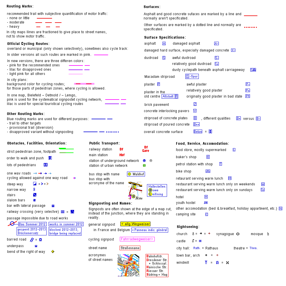
– English Entrance to www.radweit.de –
radweit-routes are designed to encourage long distance cycling. Therefore they avoid detours, difficult sufaces, roads with a lot of motor traffic, and heights.
Where a compromise between detour and heights is afforded, the optimal route has been choosen by the guideline, that 100 meters of ascent eke out 5 km of detour, and vice versa.
radweit-routes have been tested entirely, and they are tested again from time to time.
Designed only to fit the purposes of the cyclists, radweit-routes are independent from official signposting. So they are merely recommendations. Sections of signposted cycle routes and built cycle tracks are only used, where they are useful for the destination desired.
All radweit routes are bidirectional, but sometimes for sections of them, there are different recommendations for the directions.
Routed area:
Up to now there are more than 20,000 km in Germany and some routes in eastern France, Belgium and the Netherlands, few in other coutries. The reason of this geographical concentration is the effort for maintaining actuallity. Many of the routes are intended (and have been used) for cycle tours to targets far away from Germany and eastern France.
Presentation:
The routes are marked in strips of topographic maps 1 : 100,000, composed in collages of A 4 paper seize. The cuts are numbered. Their junctions are marked by minuscules. If the presentation of one route requires more than one A 4 seized collage, the maps are numbered in most routes by capital letters, in some routes by Roman numerals.
The "Startseite" (start page) includes a list of all routes and maps, alphabetical according to their nominal starting points.
There are three interactive survey maps of "all" routes, combined with a list of the routes (of course interactive, too), alphabetical according to both ends of each route.
To go to a chosen map, one of the coloured dots (6 x 6 pixels) has to be clicked. The different colours of the routes in the survey maps only serve their identification and don't tell anythng about the properties of any route.
• The "Kleine Übersichtskarte aller Routen" (small survey map of all routes) is very schematical, routes in France are not shown completely. The list of routes is integrated.
• The "Große Übersichtskarte" (large survey map) is a bit more detailed. It shows less area outside of Germany than the small one. The list of routes is in a pupup window
• "Übersichtskarte F-B-D", showing Belgium and parts of France, the Netherlands, and Germany. It is the only one with level colours, which have been derivred from GOOGLE MAPS ®. To maintain the contrast of routes and background, some routes are marked in different colours in this map than in the other maps. The list of routes is shown in a pupup window
The index of places only contains places of considerable relevance, not every hamlet.
Route Pages:
For each route, there is a survey page (Übersicht der Route), including small copies of the routemaps, a survey map of the whole route, often a list of distances ("Entfernungen per Fahrrad" = Distances by Bike), and sometimes some text.
The pages with the maps include only a navigation bar on top and the map itself.
All radweit maps are avaliable for print ("Druck"). The colored print version is identical with the primary map embedded in the HTML-file. Grayscale versions improve the visibility of black-and-white prints by representation of any color by a selected grey level. Greyscale print forms are also available for left & righht or upper & lower halves of the A 4 seized maps. Fixed togeter they form A 3 seized maps.
Most print forms are PDF-files for download. Due to license conditions, some print forms are hidden files, that can't be downloaded.
Viewing and printing are free of charge.
GPS:
For some routes, there are GPS-tracks available, all are stored at GPSies, some in Radreise-Wiki. Each linked from the survey page of the respective route, and mostly also from the map pages. Due to the different conditions of presentation as a map and presentation as a GPS-track, sometimes there are several GPS-tracks for one map, and sometimes several mapped routes are combined in one GPS-track.
Language:
As the maps are not vectorized, it is impossile to change the language with a click. Most of the maps are in German only. If a map shows totally or predominantly territory of France, Belgium or the Netherlands, the explanation in the map is bilingual, and HTML-files are available in two or three langages.
For English speaking readers, there is that one English explanation of keys for all radweit maps, shown below.